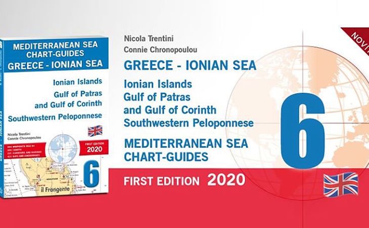
N.Trentini e C.Chronopoulou - Mediterranean sea chart-guides Greece - Ionian sea
First English edition 2020

First English edition 2020
Ionian Islands Gulf of Patras and Gulf of Corinth Southwestern Peloponnese.
 |
|
Chart-guides
Edition 1st edition 2020
Language English
Pages 280, full colour
Price € 56,00
|


© Copyright 2011-2024 - Nautica Report - Reg. Tribunale di Roma n.314 - 27-12-2013 - Editore Carlo Alessandrelli - Un marchio Wave Promotion srls - P.Iva: 12411241008


Ti Potrebbe Interessare Anche
Rod e Lucinda Heikell - I PORTOLANI DEL MEDITERRANEO - GRECIA EGEA
Saronico e Peloponneso orientale - Cicladi - Eubea e Sporadi settentrionali - Sporadi orientali - Dodecaneso - Creta. Giunto alla quinta edizione,...
Sara Rossini - Mamma & marinaia - La nostra storia con tre bambini in barca
Ma posso guidare la barca? Ma a bordo c’è il letto? Ma come si rispetta il mare? l Libro Edizione 202Lingua italiano Pagine...
Luca Tonghini - PORTOLANO CARTOGRAFICO 17 - Montenegro e Albania
GRECIA Corfù e Paxos - ITALIA da Bari a Capo Rizzuto. Questo portolano, costituito da 166 tavole cartografiche, descrive in dettaglio le...
Giuseppe Accardi - GMDSS - 2 Guida all'esame
Per il conseguimento dei certificati di Operatore Radio GOC, ROC, LRC e SRC, per l’utilizzo di VHF-DSC, MF/HF-DSC, AIS attivo, EPIRB, Inmarsat e...
Sacha Giannini - OSMOSI. Come orientarsi tra dubbi e soluzioni, consigli pratici...
L’argomento osmosi è da molti anni tra i più discussi e temuti nel mondo della nautica, soprattutto in Italia. Nell’immaginario...
Luca Tonghini - PORTOLANO CARTOGRAFICO 16 TURCHIA E GRECIA - Da Marmaris a Finike...
Questo portolano descrive uno dei tratti più suggestivi della costa sud della Turchia da Marmaris a Finike e le isole greche di Rodi e Kastellorizo. Il...
Bill Johnson - IL RADAR IN BARCA
Traduzione dall'inglese di Chiara Albericci Il manuale Edizione 2023 Lingua Italiano Pagine 120 ill. a colori Formato...
Gino Corcione - LA MURENA UCCIDE IN SILENZIO I gialli del mare
Napoleone Esposito ha appena concluso con successo l’operazione di recupero dei preziosi reperti archeologici rubati al Museo di Tarquinia. Il...
Giancarlo Pedote - ''Proteggiamo l'0ceano'' Il primo libro dello skipper toscano...
Giancarlo Pedote, rinomato navigatore oceanico, presenta con orgoglio il suo ultimo lavoro, "Proteggiamo l'Oceano". Il libro è disponibile nelle...